Maximize Your Corn Harvest With Drone Plant Counts
May 19, 2021
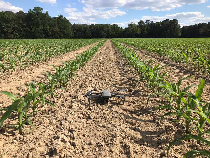
Crop stand establishment directly affects yield. But often we don’t know what this season’s or any field’s limiting factor is. Some field crops can overcome mediocre establishment but others, like corn, suffer from sparse or bunched spacing. Fortunately, uneven corn field establishment can potentially be remedied with quick and precise replant decisions — if you know where and how to respond. Having a very accurate plant stand count for each field row can reveal the cause of losses and the opportunity for recapture.
Corn Stand Establishment Influences Yield
Stand establishment is impacted by variability in plant population, seedling emergence, and in-row plant spacing. Agronomic research from Purdue University shows that 60% of commercial corn fields could improve yield by 50% (from 5 to 7.5 bushels per acre) simply by unifying plant to plant spacing.
Iowa State University’s corn stand assessment guide also shows a clear link between corn plant population, planting dates, and expected harvest. The steady decline in expected yield from low plant population or late timing emphasizes the importance of strong corn stands and, if necessary, quick replant decisions.

But it’s hard to improve establishment if you can’t identify the problem.
What Factors Affect Corn Stand Establishment?
Seed quality and many other variables affect seedling emergence. Environmental factors of weather and soil conditions affect soil temperature and available soil moisture aids germination. Mechanical issues like equipment condition and practices can also influence spacing variability. And finally, other external factors like weeds, pests, and disease can be limiting factors on productivity all around.
With so many components to balance across large acreage, it’s challenging to fully and accurately assess corn stand establishment. But this year’s harvest is riding on those early season decisions. How can you get the best information to maximize each field’s productivity? It starts with accurate scouting data.

Download The Drone Crop Scouting Schedule™ for FREE
Learn when to fly a field for actionable decisions and peak profits
Get your free pdfEfficient Crop Scouting Leads To Precision Decisions
Early-season crop scouting is essential to catch and consider replant opportunities. But crop scouting is time-consuming to do on foot and rarely captures the entire field. Drone crop scouting is the solution to quickly and comprehensively map corn fields.
But field imagery alone isn’t enough. To make precise decisions you need a combination of location-specific data and statistical analysis. In other words, you need more than a map, you need an action plan.
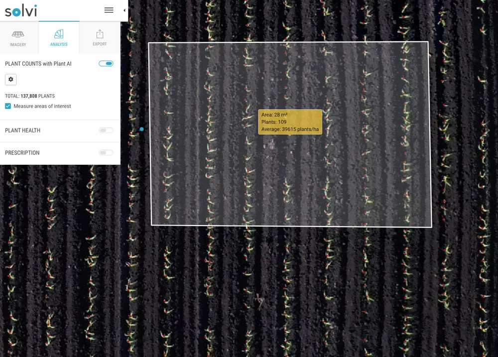
Calculating traditional stand counts requires representative field sampling (done on foot) followed by lengthy statistical analysis. The results are useful but the process is cumbersome and the results merely anecdotal. Solvi’s Plant Counts with Plant AI™ converts drone-collected field data into actionable insights to use this season.
Plant Counts Shows The Big Picture

Solvi’s Plant Counts provides a complete view of every row in your field. Our deep-learning algorithms then perform the statistical analysis for you to visually highlight trouble spots. Now you can stop wandering the field and save time by walking directly to hot spots for diagnosis.
Plant Counts saves scouting time and speeds decision-making for replanting or other management options, like weed control. Best of all, Solvi’s full drone analytics suite can power precision management software to create prescriptive files that quickly become your action plan for variable rate replanting.
Zonal Statistics Reveals Spacing Variability

Minimizing plant spacing variability is an essential factor in maximizing corn growth and yield. But calculating these detailed statistics is cumbersome, requiring multiple in-row hand-measurements. Ultimately, the results are just a representative field sample, not a complete view.
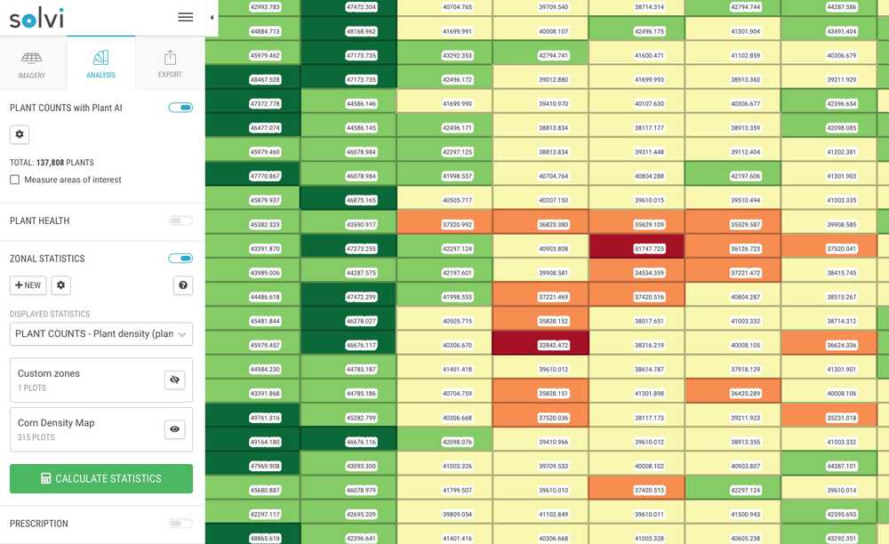
Solvi’s Zonal Statistics tool takes your plant count data even further. It allows you to split the field into smaller zones and calculate plant density within each zone, highlighting areas with lower and higher plant populations.
The size of the zones can be adjusted to any dimension to adapt to your field and planting equipment. To create an actionable file, export the mapped zones as an SHP file for use in precision machinery or farm management software.
Solvi Simplifies Drone Analytics
It may sound complicated, but we handle the mathematical heavy-lifting. Solvi’s easy-to-use software provides precision crop analytics in less than 30 minutes to anyone - without a Ph.D. in statistics. Here’s how it works:
- Collect field imagery at key decision-making times (after emergence or weed management)
- Upload your drone imagery file (RGB or multispectral from any drone and camera)
- Get an accurate number of plants in the field and a visual overview of plant population variability
- Use GPS location tool to walk directly to trouble spots for localized diagnosis
- Use Solvi’s exported counts in your precision management software to generate prescriptive files for in-season replanting
Solvi also offers ‘done for you’ analytics services. Outsource your analytics for high-volume users or complex setups. Our support team handles the work for you and provides the same precise results within a day. We’ll do the data, you do the decisions.
Precision Decisions Start With Actionable Data
Drone crop scouting can’t replace your boots in the field. And it isn’t meant to. But it can be a time-saving ally to direct your crop scouting efforts for the most efficient use of your time. Armed with precise data, you can make the most of this year’s promising corn season.
Additional Resources:
- Stand Establishment Variability In Corn, Purdue University
- Corn Stand Assessment, Iowa State University
- Checking Stand Establishment of Small Grains and Corn, North Dakota State University
- Stand Establishment Critical For Early Planted Corn and Soybean, Iowa State University
- Considerations For corn Stand Establishment, Dekalb/Asgrow/Deltapine
