Scaling Multispectral Drone Data in Agricultural Trials
March 30, 2022
The AgroTech division of Danish Technological Institute (DTI), a non-profit approved technological institute within agriculture and food, standardized their drone image processing and liberated their digital desktops from volumes of multispectral images by integrating Solvi’s drone image stitching into their proprietary workflow. In addition to the mountain of time and desktop storage saved, they discovered how Solvi’s shareable cloud links keep their multifaceted team working from the same page.
Since 2018, DTI has used drones to collect and analyze objective research data in a consistent, repeatable process - on a grand scale. Their substantial challenge was melding scads of data from multiple sources while ensuring accurate, objective datasets for analysis and sharing.
Our goal is to collect relevant data from our high-volume field trials in a cost-effective method. By collaborating with local field trials units and SEGES, it has been easy to scale up our use of drones nationwide.” - said Thomas Nitschke DTI’s Project Manager.
Details
Crop: National field trials for SEGES and private field research on multiple crops, treatments, inputs
Location: 8 Research locations across Denmark
Farm size: 1,000 field trials/year
Partner: Danish Technological Institute
Hardware: DJI Inspire 2 equipped with MicaSense Altum. Local collaborators use the DJI Phantom 4 with a MicaSense RedEdge-MX
Software: Solvi Multispectral Imagery Stitching, Plant Health Maps, Zonal Statistics and Sharing tools
Flight Altitude: Normally 40 m height, up to 60-70m AGL in strong winds or large fields, or as low as 30m for higher details
Number of flights: Up to 21/ week during the growing season, 443 flights total in 2021
Image resolution: Highest level of detail (lowest GSD possible) depending on camera and altitude. Around 1.3 cm/px at 40 m AGL with the MicaSense Altum
Situation
In addition to public and private research field trials, DTI conducts the Danish national field trials on behalf of SEGES, a farmer-owned non-profit. For those field trials alone, DTI coordinates 18 drone pilots from multiple organizations to fly the research units countrywide.
To date, DTI has collected over 2,000 multispectral datasets on NDVI/NDRE, plant height, coverage, germination, and more. Study results are regularly published for stakeholders in the Nordic Field Trial System.
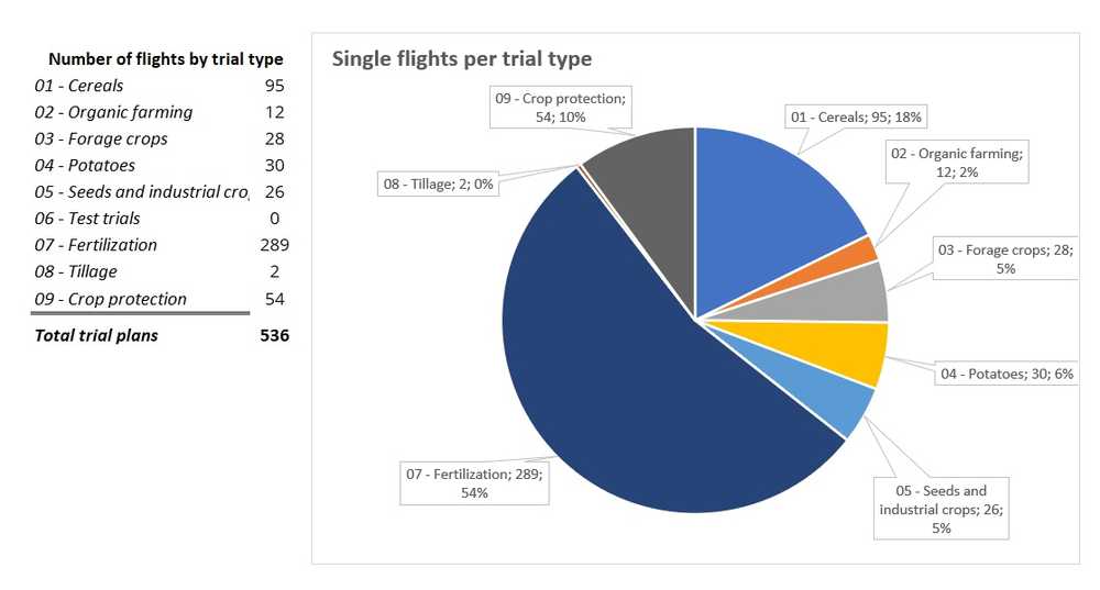
DTI’s 2021 drone flights covered:
Improving drone data collection and efficiency was job one. DTI employs MicaSense’s multispectral sensors for virtually all of their research drone imagery. These advanced instruments reveal novel field data imperceptible to the human eye and extremely valuable to DTI/SEGES’ research. But this high-value data comes at a cost.
To produce vivid imagery, multispectral sensors generate droves of image files (5-10 times more compared to RGB imagery). But not all images accurately contribute to the final orthographic composite. A few rogue, poor-quality images could derail the stitching process or affect the study’s data validity.
DTI uses MicaSense’s multispectral imagery to calculate vegetation indices (primarily NDVI and NDRE) to assess crop biomass and validate differences between individual trial experiments. But DTI’s high-res image stockpile is also building a plant health database that will be a vital future reference.
The drone imaging program in the National Trials has provided a lot of useful data at a very high degree of accuracy and time-efficiency,” Nitschke said. “Having such a large historical database of multispectral data from so many different experiments increases the data’s scientific and economical value in the future.
DTI’s flood of data-rich drone images offered an accumulating high-value research asset if they could harness the workflow. DTI’s research volume and complexity necessitated a seamless solution to bridge the data to the deliverable for a sizable team.
Download The Complete UAV Handbook for Agricultural Research
Learn how to establish a successful drone imaging program without a data scientist
Get your free pdfResearch Goals
- Amass comparable research data efficiently and objectively
- Coordinate research trials across multiple sites, crops and teams
- Evaluate research trials with a focus on biomass and crop height
- Regularly report findings to stakeholders in a digital format
Workflow Strategy
DTI layers georeferenced technology from satellites, drones, and field sensors to cost-effectively expand their experimental datasets. But each data layer can be time, labor and storage-intensive.
To leverage the detail without the drag, DTI opted to outsource its drone image stitching, storage, and sharing to ultimately integrate into a proprietary analytics methodology. The result is a customized, highly efficient and accurate process to extract the maximum value from their research time.
Drone Research Imagery Applications
1. Data Processing or Handling
Image Preview
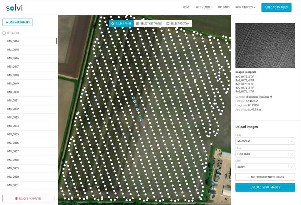
Multispectral sensors generate thousands of photos per flight. Evaluating outliers that can skew data interpretation or corrupt image stitching is nearly impossible to do manually. Solvi’s preview feature allows users to see their image stream plotted across the field on a map. Now users can quickly identify and reject any blurry, off-target, or unrelated images among thousands of valid images.
Solvi’s upload interface makes it really easy to detect and select images that would disturb the final stitching, or check whether there has been homogeneous coverage of the flight area,” said Nitschke. “And they are frequently developing new tools and improving the UI to improve the final user experience which makes their service even more straightforward.
High-Speed Upload
Each drone pilot uploads imagery directly to Solvi following standards for marking, calibration, altitude, speed, and camera type. Because each flight must be comparable, DTI developed an image capture and processing protocol handbook for their 18 drone pilots.
Solvi’s cloud-based platform allows DTI pilots to upload volumes of multispectral imagery over a high-speed connection, saving time by batching flights and transfers. Once uploaded, the stitched imagery is available in a matter of minutes for smaller trials, or within about an hour for larger ones.
Image Calibration
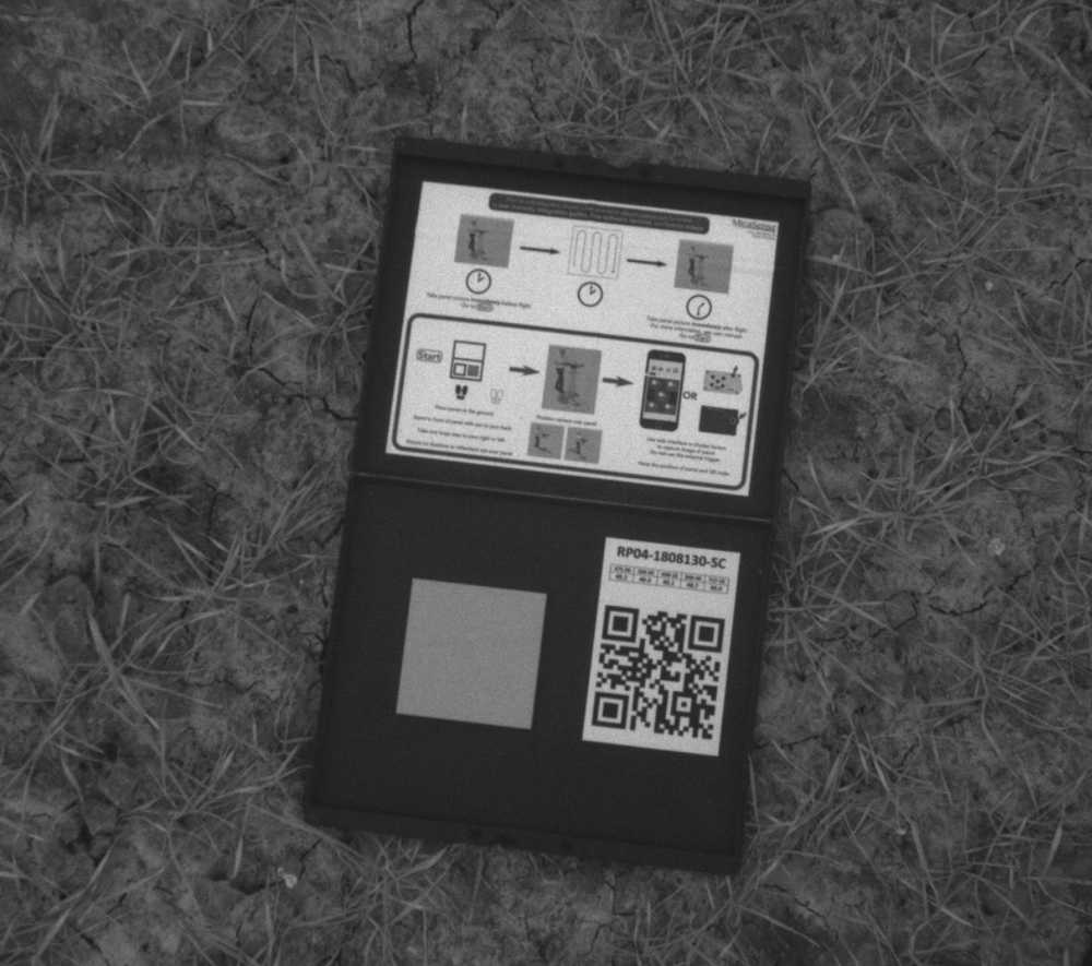
Calibrating the imagery so that the variable light conditions on the day of flight are taken into account is crucial when processing multispectral imagery for research. Without calibration the NDVI/NDRE data cannot be compared across multiple flights and locations or even with satellite data. To address the issue, DTI pilots use the calibration panels with known lab-established reflectance values. Images of such panels are taken before and after each flight and uploaded along with the images over trials. Solvi automatically recognizes such panels during the processing and makes the necessary adjustments. As a further enhancement, the data from the DLS (Downwelling Light Sensor) can optionally be used to accommodate changing light conditions during the flight.
2. Trial Plot Boundaries
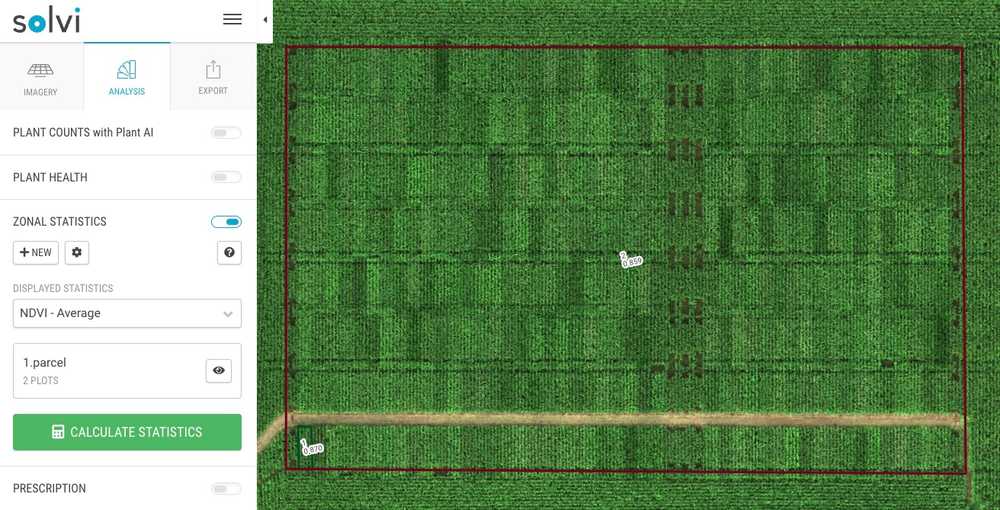
Due to the size and intricacies of their trial designs, DTI prefers to data-mine in-house. After reconciling and uploading imagery, DTI uses Solvi’s Zonal Statistics to isolate research fields and mark plot boundaries. Each flight is then exported for further study.
With a downloaded shapefile, DTI exercises its own R-script to annotate field layout and begin proprietary analyses. For DTI’s unique process, Solvi’s integration flexibility has been a seamless match.
Since our orthophoto processing is centralized at DTI, while the trials are spread across the country, it is impossible to know the exact placement of each plot or how big the trial is,” Nitschke said. “We use Solvi’s Zonal Statistics as a standard tool to mark trial areas and plot rows. Based on Solvi’s output and our trial design, DTI researchers can identify and label every plot from the pilots’ uploads.
3. Web Sharing
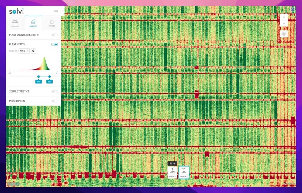
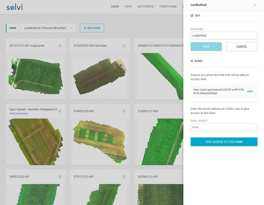
Capturing and processing imagery is only half of the equation. To be useful for analyses, data also needs to be accessible to the entire team. DTI uses Solvi’s web-share links to access finalized photos in a central sharable cloud where researchers can visualize data metrics and even publish these impactful snapshots to the NFTS database.
We often use Solvi’s web-share links, which allows everyone involved in the field trial to easily access the orthophoto and see the visual representation of data in the “plant health” menu.
4. Data Download & Integration
Combined with other georeferenced data sources, Solvi’s drone data visualizations are so potent that DTI uses them to power their white-labeled “OnFarm Plus” dashboard for private clients.
Solvi’s flexibility allows users to choose where to perform analytics. Data points for plant counts, plant health (like NDVI and NDRE), as well as elevation and orthomosaics, are easily downloaded in GeoTIFF, SHP, Excel or CSV formats for offsite evaluation.
Drone Research Imagery Outcomes
- Standardized, repeatable trial data collection for improved data quality
- Volumes of objective data in a fraction of the time
- Common access point and informatics for a community of collaborators
- Compelling visual reporting for stakeholders
- An insight-rich data layer to power a marketable product and revenue stream
There are a lot of benefits to the operation by collecting data with drones. Time, and therefore money, sure have value. However, from the scientific point of view, what matters the most is broadening the number of information gathered about experiments and the quality and trustworthiness of such data, which lies in the objectivity and repeatability of the measurement technique.
Benefits of Solvi Analytics
Processing & Integrating Large Volumes of Drone Data in the Cloud
Large teams and elaborate trial designs demand reliably repeatable processes. DTI partnered with Solvi to bridge data sharing among their field and home offices, clients, and end-users. Reliable, efficient data collection is yielding sound research with economic viability.
But many multispectral users succumb to the desktop drag of substantial storage demands. These insight-rich images can hog 10-20 GB per flight! Mastering multispectral imaging requires an agile image processing workflow.
Solvi’s cloud-based platform allows users to upload and download large files over high-speed connectivity while storing, managing, and sharing large datasets away from their personal desktops.
- Complete all in one cloud-based platform.
- Flexible to work with any RGB or multispectral camera and drone combination.
- Simple four-step imagery upload process.
- Highly accurate plant counts and health analytics.
- Clear, visual plot boundary maps and data results for research reports.
- Easy online sharing for full team access.
- Streamlined data exporting for offline use or integration.
DTI’s imagery volume and internal process is unique. But Solvi offers all that is needed from a farmers/agronomist and trial facility point of view,” Thomas Nitschke said. “We have been pleased with Solvi’s as a platform, as well as from the responsiveness of its customer support, look forward to continuing our collaboration.
